Newport
Lake Washington on one side, wooded hills on the other, with a small shopping center above the freeway.
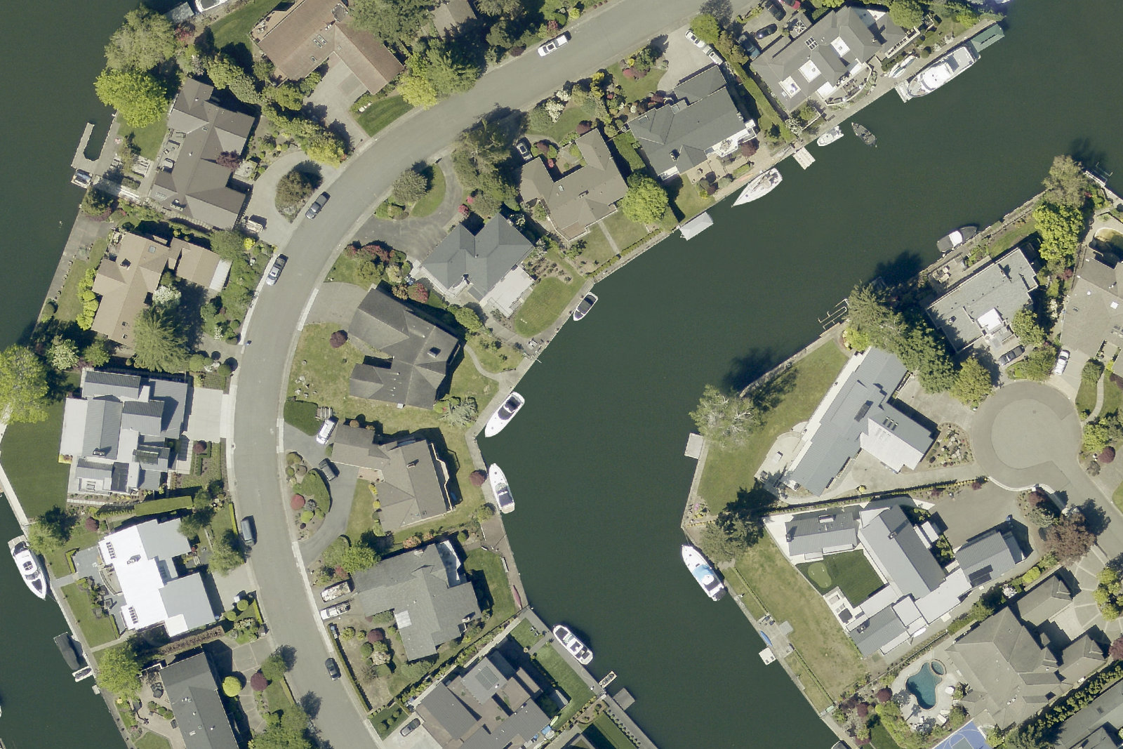
Coal and timber once travelled through Newport to boats on Lake Washington; the old rail corridor is becoming Eastrail. Newport Hills was platted in 1958, followed by its shopping center in 1963. Today the city's Newport area takes in both the lakeside streets west of I-405 and the hills east of it.
- Homes
- Median sale: condos $322,000, houses $1.44 million
- Schools
- Newport Heights · Tyee · Newport · 31% Renton district
- Getting around
- Metro 240 serves the hill and South Bellevue Station; Eastrail runs west of I-405.
Living here
Where to go
Newport's outings run from the lakeshore to wooded ravines. The Coal Creek photograph below is from the park's upstream stretch in Newcastle; check the city's trail notices before choosing an entrance.
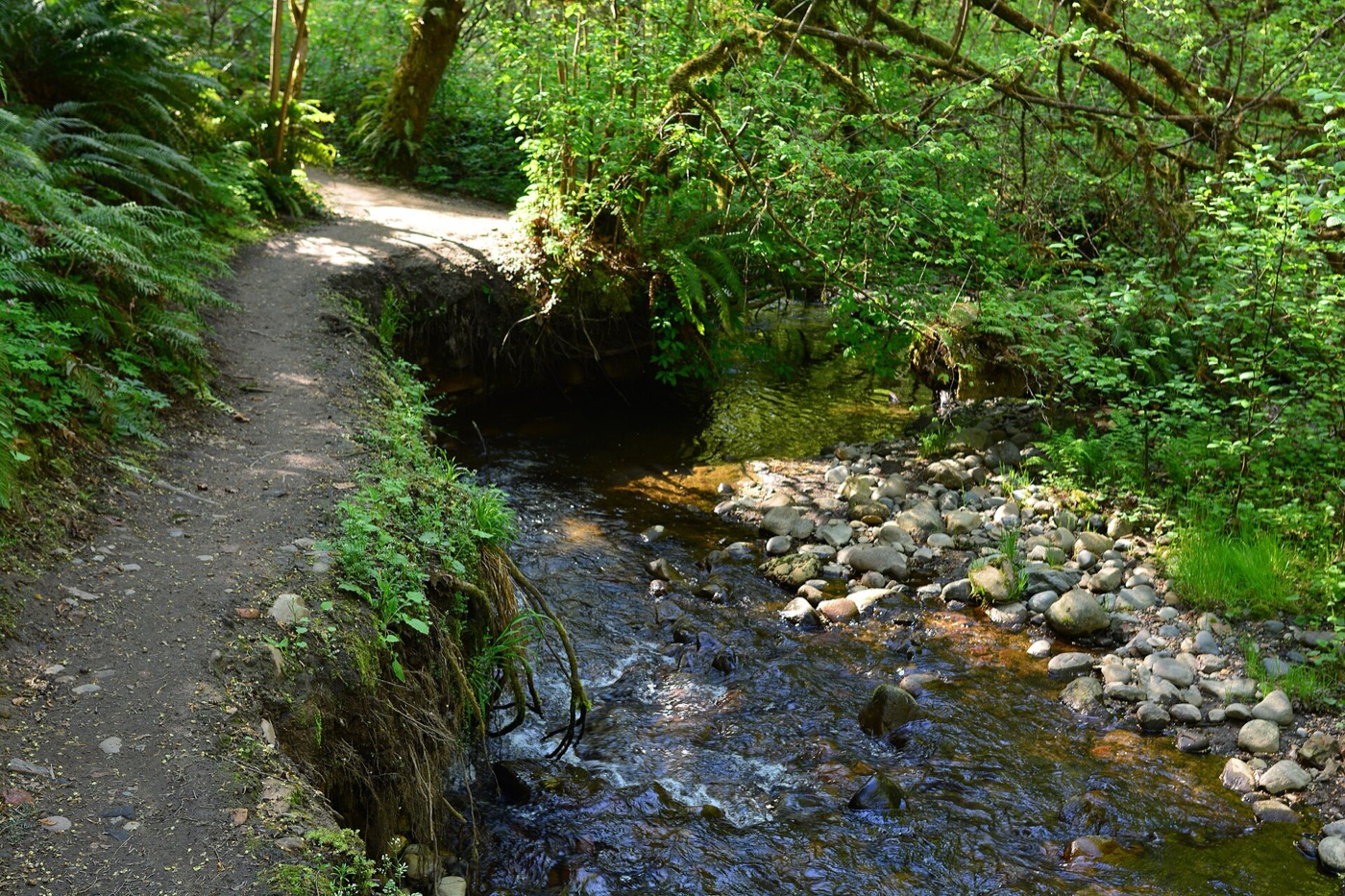 Along Newport's eastern edge and upstream into Newcastle
Coal Creek Natural Area
A wooded creek walk extending beyond Newport. This frame is on the Primrose Trail upstream in Newcastle; Red Cedar Trailhead is closed, so choose an open entrance from the city's trail guide.
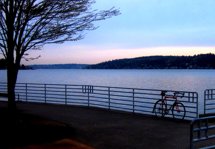 4400 Lake Washington Blvd SE
Newcastle Beach Park
Lake Washington access with a swimming area, dock, nature trail, picnic space and a launch for non-motorized boats. Check the city's page for seasonal lifeguard and closure notices.
- Photo coming11560 SE 60th St
Newport Hills Woodlawn Park
Forest loop paths, a lawn, a fenced dog area, exercise and play equipment, picnic tables and restrooms.
- Photo coming6029 120th Ave SE
Newport Hills Park
A play area, soccer and ball fields, and restrooms on the hill.
Where people live
Detached houses follow curving hillside streets and the canals of Newport Shores. Apartments and townhomes cluster near the Newport Hills Shopping Center, with smaller groups along Coal Creek Parkway, Lake Washington Boulevard and in Pembrook Meadows. The freeway splits the lakeside streets from the shopping center on the hill.
- Detached houses82%
- Townhouses and plexes8%
- Condos6%
- Apartments4%
- Detached houses 3,159
- Townhouses and plexes 324
- Condos 219
- Apartments 159
- Not housing
What homes here sold for in the year to 14 October 2026, from the sales King County records.
Houses and townhouses$1.44 million median 76 sales · Bellevue $1.89 million
Condos$322,000 median 14 sales · Bellevue $615,000
A median describes the homes that happened to sell, not every home here. Only ordinary sales count: estate, family, foreclosure and multi-parcel sales are left out. A type with fewer than 10 sales shows no median. Rents are not public record.
Schools that serve it
Bellevue School District assigns schools by address. Each bar is the share of the 3,500 addresses here that a school serves.
- Newport Heights67%about 600 students
- Tyee66%about 1,060 students
- Newport66%about 1,850 students
About 31% of addresses here are in the Renton School District.
From the attendance areas the City of Bellevue maps for the district, read 25 August 2026. Boundaries change and an address near a line can differ: confirm with the district’s school locator. Choice and application schools have no attendance area and are not listed. Enrollment is each whole school’s, all grades, from the OSPI Report Card for 2025-26 (data as of 1 June 2026), rounded to the nearest ten; it counts every student, not only those from here.
Getting around
More about this map
Geometry simplified to about 12 metres. Station point is the platform centre. The frame is the area plus a few hundred metres; only routes with a stop in the area or at its edge are drawn, each direction, variant and carriageway as one line; routes within 60 metres of each other share a road and are drawn side by side.
- Metro GTFS: 20260928 to 20270326 (FAL26-161.2); retrieved 2026-10-27.
- Sound Transit GTFS: 20261001 to 20270326 (SC-Fall-2026.5); retrieved 2026-10-27.
- OpenStreetMap snapshot: 2026-10-24T20:20:51Z; retrieved 2026-10-27.
Sound Transit 560 also stops at Newport Hills Freeway Station on its way to the airport; check its current schedule.
| To | How | Typical trip |
|---|---|---|
| Downtown Bellevue | Metro 240 | about 34 min |
| South Bellevue Station | Metro 240 | about 22 min |
| Downtown Seattle | Metro 240 → 2 Linechange at South Bellevue | about 51 min |
| Sea-Tac Airport | Metro 240 → 2 Line → 1 Linechange at South Bellevue, International District/Chinatown | about 84 min |
Scheduled times on 29 October 2026, a weekday: the median over the buses leaving 119th Ave SE & SE 56th St or 119th Ave SE & SE 54th Pl between 10 a.m. and 2 p.m., from boarding to arrival, waits to change included and the walk to the stop not. From the Metro and Sound Transit GTFS, read 29 October 2026. Check the agencies before travelling.
What’s changing
The city’s plan for Newport
Newport's neighborhood area plan was adopted on 21 October 2025. The cards' ‘The plan would’ describes what carrying out those adopted policies would change, rather than a pending vote. The city's report supplies the baseline conditions; the trail schedule below comes from current project pages. No next Newport area-plan decision is posted in the Great Neighborhoods schedule.
The shops on the hill
NowThe Newport Hills Shopping Center anchors the commercial strip on 119th Avenue SE; the city's baseline report records vacancies and underused space.
The plan wouldBring buildings up to the sidewalk, make room for small independent businesses and work to retain tenants through redevelopment, with apartments and mixed uses in the center (S-NP-8–10, S-NP-12). Adoption does not mean a replacement center is under construction.
Somewhere to gather indoors
NowThe area's swim and tennis club and yacht club are membership spaces. The adopted plan identifies a need for additional indoor gathering places.
The plan wouldPartner on accessible, affordable meeting places and community uses of school-district property, including a facility that could help during emergencies (S-NP-13–16). No opening date is attached to those policies.
Parks and their entrances
NowNewcastle Beach provides lake access; Newport Hills Park has sports fields, while Woodlawn combines woodland paths, lawn and a dog area.
The plan wouldSupport parks that can host events, acquire sites connected to trails, improve entrance signs and link public paths across land managers (S-NP-17–18, S-NP-23–27).
Across I-405 to the lake
NowI-405 divides the hills from Newcastle Beach and Eastrail, with limited places to cross. The county's I-90 trail-bridge project remains in design.
The plan wouldImprove walking and cycling connections to Eastrail and work with WSDOT on the Lake Washington Boulevard interchange crossing (S-NP-30–31). The I-90 gap is a separate county project anticipating a 2031 opening.
The bus and the walk to it
NowThe 240 serves the hill, but winding streets and incomplete walking connections leave some homes away from a convenient stop.
The plan wouldExpand transit connections to rail and downtown, calm traffic, and strengthen the pedestrian and bicycle networks (S-NP-21–22, S-NP-28–29). The plan does not promise a new rail station in Newport.
Creeks, trees and the lakeshore
NowWooded ravines connect Newport's parks and streams; development and trail access share this landscape with sensitive habitat.
The plan wouldProtect trees on slopes, connect habitat across parks, improve access to water with ecological care and reduce polluted runoff (S-NP-6, S-NP-32–35).
These are policies the Council adopted, not funded projects: none comes with a budget or a date unless its card states one.
Where it stands
The Council initiated the Newport and Crossroads area-plan amendments.
Newport's public hearing closed with a Planning Commission recommendation for adoption.
The Council adopted the Newport Neighborhood Area Plan. Its numbered policies are the ones summarized above.
The Council approved the separate Housing Opportunities in Mixed-Use Areas code amendments. That approval is not a development start date.
Every meeting in the process (12)
The Planning Commission received the initial briefing on the Newport planning process.
A virtual kickoff introduced the two neighborhood planning rounds.
Newport's Ideas Fair took place at the Newport Hills Swim and Tennis Club.
The city issued notice of the Newport area-plan application.
Newport's virtual project update presented the emerging vision and policy ideas.
The Newport public-space workshop examined streets, trails and gathering places.
The Planning Commission reviewed progress on Newport and Crossroads policies.
The Council received the neighborhood planning progress report before the full drafts.
The Parks and Community Services Board reviewed the Newport and Crossroads plan updates.
The Arts Commission considered the two neighborhood planning updates.
The Planning Commission examined the full Newport draft alongside Crossroads.
The Council reviewed the recommended Newport plan before its adoption meeting.
What’s coming
No opening with a confirmed date is listed here yet.
How this was checked
Boundary: the City of Bellevue’s Neighborhood Areas layer, the Comprehensive Plan’s planning areas. Place information was checked against the sources and dates under Sources.
Schools: every addressed parcel the city publishes, placed in the district’s attendance areas and, outside them, in the city’s school-district layer. A school serving under 5% of an area’s addresses is left out. Enrollment: OSPI’s Report Card enrollment on data.wa.gov, the all-students count for each school, read by scripts/neighborhood_enrollment.py.
Home prices: the King County Assessor’s Real Property Sales extract, ordinary sales of houses and condos by warranty deed with no non-market flag, placed by parcel number in the city’s parcel layer (a condo by its building).
Sources (7)
Sources
- History, boundary and adopted policies: City of Bellevue, Newport Neighborhood Area Plan, S-NP-2–5 and S-NP-10–12; Existing Conditions report, pages 5–6, 11–12, 19–25. Read 27 October 2026. Conditions describe the report period, not a new street audit.
- Plan process and adoption: Great Neighborhoods, its archived meetings, and the city's adoption announcement. Read 27 October 2026.
- Parks and access: city pages for Coal Creek Natural Area, Newcastle Beach Park, Newport Hills Park and Newport Hills Woodlawn Park. Read 27 October 2026; the Red Cedar closure is a current notice.
- Buses and station: Metro 240, 111 and its GTFS feed; Sound Transit South Bellevue Station and 560. Read 27 October 2026. The saved map joins active Metro trips and stops; route 560 is described separately. Check agency alerts before travelling.
- Future trail links: King County Eastrail projects and Bellevue's Eastrail connection at the Greenway. Read 27 October 2026. The county now gives 2031 for the I-90 gap, superseding the report's older 2030 estimate; both project schedules can change.
- Separate housing-code decision: Housing Opportunities in Mixed-Use Areas, approved 17 March 2026. Read 27 October 2026; this is not a Newport construction or opening announcement.
- Homes imagery: public-domain USDA NAIP acquired 7 October 2023, selected through the city's parcel layer and Planetary Computer, read 27 October 2026. Each frame centres on an actual parcel nearest a residential zone's median centroid inside Newport. The layer's zone labels are snapshot classifications, not claims about current development rights or the building type in a photograph.
Photo credits
- Newport Shores from the air: King County, EagleView, 2025, Used with permission (King County GIS, 2026-10-22), via gismaps.kingcounty.gov.
- A narrow dirt trail follows a wooded bank immediately above Coal Creek: Joe Mabel, 2026, CC BY-SA 4.0, via Wikimedia Commons.
- A bicycle leans on the waterfront rail at Newcastle Beach Park at dusk: Gene Bisbee, 2012, CC BY 2.0, via Flickr.